Thursday, April 11, 2019

Winter Travels 2019--Part 28: Time in Yuma


For several reasons, we wanted to drive into Yuma on Wednesday.  We started at the main Library, where we had minimal data access but Marv downloaded some “Grace and Frankie” shows for us to watch on his tablet when we don’t have electricity and I talked to the reference librarian about things to do in Yuma. She printed a Yuma hiking and biking trails map for us and suggested we go to the Visitors’ Center on Avenue B for more information. From there we could bike east along the Colorado River to Gateway Park and into the Historic Downtown district of Yuma. The town was only truly formed in 1914 and the district is about 3 blocks long, once containing the Post Office, a bank building, JC Penney, and a saloon and ballroom or two. The recommended place, Lute’s Restaurant, was very busy with people waiting out front to get in and so we went on to Prison Hill Brewery for lunch. Its beer and entree names were cute twists on prison lingo and it notes that the Brewery is crawling distance from the old Territorial Prison, notorious for having the first 7 inmates build their adobe cells themselves and then incarcerating them in them. The prison is now a State Park and you can see the original cells on the hill nearby.
_DSC0283
We returned to the river trail and followed it west to the West Wetlands Park and back to a different trail to Pivot Point Park. Yuma has been known for centuries as the narrows for, and only crossing for, the Colorado River. In 1540, Spanish colonial expeditions under Hernando de Alarcon and Melchior Diaz visited the area and immediately recognized the natural crossing of the Colorado River as an ideal spot for a city. The Colorado River narrows to slightly under 1,000 feet wide in one area. Military expeditions that crossed the Colorado River at the Yuma Crossing include Juan Bautista de Anza (1774), the Mormon Battalion (1848) and the California Column (1862). During and after the California Gold Rush to the late 1870s, the Yuma Crossing was known for its ferry crossings for the Southern Emigrant Trail. This was considered the gateway to California, as it was one of the few natural spots where travelers could cross the otherwise very wide Colorado River.
Photo 02-14
The crossing was controlled by the Quechan Indians until the US Army took it over during the Gold Rush and also acquired thousands of acres of rich ancestral farmland. Recently some of the land has been restored to the tribe and they have been primary planners in restoring the wetlands that have been destroyed as people have tried to tame the Colorado River. In fact, because of the extensive dams, canals, settling tanks, and agriculture along the lower Colorado, it is a dead river with no water by the time it reaches Mexico, just 20 miles away. As you can guess, Mexico isn’t very happy about that…
After riding about 7 miles altogether, we did some grocery shopping and got to a Brewers Sports Bar that had the Big Ten Network and could show us MSU’s basketball game against Rutgers, their first game without the injured Nick Ward. It was another harrowing game, where they were down about 12 points at the half but pulled ahead and won convincingly by the end.

Friday, March 22, 2019

Winter Travels 2019--Part 28: More at Squaw Lake

Tuesday afternoon we drove the truck on the gravel trails/roads through the very extensive BLM campgrounds in the area. On the other side of the high levy with the road into our campground is Senator Walsh Lake, where they pump water up to fill the lake and then release it through a power generator around the bend of the river into Squaw Lake. Our neighbors (Canadians, like so many others we see in the southwest) told us they have camped beside the lake in the past and woke up to find that the lake was nearly gone, released during the night to generate power. On our way back we climbed up Hurricane Ridge, on the opposite side of the lake from our campground. Marv was occasionally getting enough signal (I never had any phone or data while at the campground) to see that the weather forecast was still pretty awful in Tucson right through the week, with a 90% chance of rain and a high of 46° on Friday. Yuma was supposed to be sunny until Thursday’s rain, and then back to sun, so we decided we’d stay an extra day and move back to Tucson on Friday. In the meantime, it was a beautifully clear night, allowing us to get some good shots of the biggest Super Moon we’ll have until 2034.

The view of Senator Walsh Lake from high atop Hurricane Ridge.

This funny reindeer was up on one of the highest hills on Hurricane Ridge.
We realized the next night that its Solar Lights could be seen from the road.

Super Moon!

Super Moon rising over the hills at Squaw Lake


Friday, March 8, 2019

Winter Travels 2019--Part 27: Squaw Lake Campground

There is very little to do at Squaw Lake but we entertained ourselves pretty well. Monday morning the wind died enough that we blew up our kayak and took it out for a long paddle on Squaw Lake. 
Looking across the lake as we paddled out.

Looking back at the campground from out in the lake.

That's our trailer up there, as seen from the lake. Palm trees sur-
rounded the lake in many places, and were on a small island in the lake.
After lunch we hiked up the surrounding hillsides to an overlook for the Colorado River and Squaw Lake, looking for but never seeing the wild burros and horses that reside in the area (as evidenced by lots of droppings). The hills are unlike anything we have seen before. They look like a pile of rubble, loosely held together, but not cemented, with dry soil. We also enjoyed lots of reading, in the sun during the day, and in the trailer at night. 
In the distance we could see the smoke of the fire which we had driven through the day before.
It looked like a prescribed burn to us, but we found out later it was actually a wild grass fire,
which continued to smolder the whole time we were at Squaw Lake, Luckily, we couldn't smell
the smoke from the campground.

The trail sometimes clung to the side of the hill precariously.
There were many washes and hillsides to climb.


That's a wide spot in the Colorado River on which we saw an occasional boat.


From up here one can see the inlets and peninsulas of Squaw Lake.


Some of the trails were actually made by the wild burros that still use them.


Winter Travels 2019--Part 26: Seeking Sunshine in Yuma, AZ

Feb. 17-22: While I took a shower Sunday morning, Marv looked carefully at the solar panel and found some wires had pulled out. He fixed it and we anticipate much more success from now on with charging our trailer battery. After scrambled eggs with lots of veggies in them, we closed up camp and dumped our tanks, getting on the road to Yuma by about 10:30. We drove south on I10 to a highway that cut across barren and mostly uninhabited (by people, anyway) desert at a southwest angle to meet up with I8, west to Yuma. We had a strong headwind and didn’t make very good mileage. We had a surprisingly good data signal and managed to listen to most of MSU’s basketball game at home against OSU. After a poor first half and trailing by 6 going into the break, MSU came out strong, held OSU to only 13 second half points, and beat them by 19.
We drove NW out of Yuma, across the US Army Proving Grounds, about 25 miles and came to several dams on the Colorado River, which form small lakes and a large Recreation Area. Marv had talked to someone by phone who assured us we could fill with water at the second to last spot, and find a place to camp at the last one on the road, called Squaw Lake. It was sunny, 65°, and the wind was gusting over 40mph as we set up in what is basically a large parking lot on BLM land. They have a bathhouse with flush toilets and pay showers, but no electricity or water, and we can camp here for $12.50 a day, because of our National Park passes. We backed into a spot overlooking the lake and decided this will do just fine for 4-5 days, while we wait for weather to improve in Tucson.

It was lovely to sit in the sun and read, although the winds were relentless.
Our lakeside campsite is on a bank too steep to access the lake.

Nice sunset out our window. The clouds surprised us by raining during
the night but it ended by the time we got up in the morning.

Thursday, March 7, 2019

Winter Travels 2019--Part 25: Acrosanti and Montezuma Castle National Monument

Saturday was our final full day at Lost Dutchman Mine. After watching weather forecasts carefully, and tired of clouds and cold(for Arizona) temperatures, we decided that Sunday we would go west to Yuma in hopes of finding a few days of sun, if not warmer temps. Before leaving, we decided to spend a day driving north on I17 to see some places we haven’t visited in the past. Nearly two hours north, our first stop was at Arcosanti, which Marv had discovered in the Day Trip book we had borrowed from Ken. Italian Architect Paolo Soleri coined the word “Arcology”—a mix of architecture and ecology--to express his vision of a community in which people can live and work in harmony with the environment. Appalled by Urban Sprawl, he designed a prototype city under a single roof, concentrating human activity into an energy efficient environment while leaving the vast surrounding acreage natural and undisturbed. His vision was a facility that would house 5000 people on just 15 acres. It was begun in 1970 and is only 1/10 built today. Soleri and his wife have both died, and the goal now is to maintain what has been built, while hoping to add on in the future. Our guide was a Columbian architect who had lived and worked in Arcosanti for 6 months a few years ago. He finished his schooling in November and returned to live here for a year, at least, because he loves it so much. About 75 people live in Arcosanti today, living communally and carrying on Soleri’s vision. There is a cafĂ© and a bakery, but most of their money is made from manufacturing brass bells and ceramic bells using a molding process developed by Soleri. Money is also made by holding workshops, seminars, festivals, and performances by visiting artists through the year. Some people living in Arcosanti have been there for 40 years. New people come in monthly, staying for varying lengths of time. Only three miles down a dirt road, it is very removed from the outside world and it is easy to get lost in the ambiance. Our guide said it is not unusual for him to go a month at a time without ever returning to the highway or the nearby town.

This is the entrance to Arcosanti. It  looks very industrial.

They use the same sand casting technique used for the bells to
make silver jewelry, like these earrings. They say that every
design is unique.

This is the outdoors workshop area where they cast the bells that they sell.


The sand casting technique was also used to make this half-dome
roof for one of the community gathering spaces. 


This is the model for the community that Soleri designed.
The angled surface was to be greenhouses down the
hill of the deep, wide wash on which it is situated.

The outdoor amphitheater is used for festivals and performances.
Running down the center of the seating area is a waterfall which
feeds a small water feature in front of the stage. It only runs for performances.


The Community swimming pool is a popular spot on much warmer days, I'm sure.

This fabric column had a fan at the top, which pushed warm air from the
dome window at the top and heated the Cafe. They take it down in the summer.

This is one corner of the Cafe, with interesting windows overlooking
the wash and hillsides to the south, letting in lots of light.
We finally had to leave so we could go a bit further north to Camp Verde. I17 rises to 4700ft. elevation before plunging down into the beautiful Verde Valley. We didn’t have time to visit Fort Verde State Historical Park, which was a regret because they were holding a Buffalo Soldiers event there. But we decided to go back further in time and visit Montezuma Castle National Monument. This was another series of Cliff Dwellings, like the others we had seen, built around 1100CE and abandoned around 1400CE. When it was completed the dwelling contained 19 rooms, some for living space and some for storage. The Verde River at the bottom, which was used for irrigating extensive acres of crops by the residents, had flooded violently from the recent rains and some of the trails are closed because of mud and debris. 
There was a magnificent view over the valley from a rest area along the way.


They are protecting Montezuma Castle (a misnomer; Montezuma would never
have been anywhere near here) by leaving it inaccessible to the public.


These beams are original, 700 year old Sycamore from the river banks.

The flooding two nights before left a lot of damage and debris.
This lower, undeveloped Castle A demonstrates that there river side was lined with
similar small dwellings resulting in thousands of people living in this common area
and trading with each other as well as others thousands of miles along a trade route.

Smaller niches in the cliff may have been used for storage.

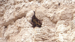
This small niche nearly at the top of the cliff had a giant bee colony inside it.
 A few miles away is Montezuma Well, a limestone sink formed centuries ago by a collapsed cavern, with more Sinagua cliff dwellings under the ledge above the water. Several tribes have creation stories centered on this deep spring, and there are five species of creatures found only in these waters, making it a very sacred and very special place.

It was after dark when we returned to our campsite, to find that the battery hadn’t charged during the day. We don’t know if it was lack of sun, or an inadequate solar panel, but it’s a good thing we will be charging tomorrow as we drive to Yuma.  


This shows the extent of the communities that lived all along the river a thousand years and more ago.

There were cliff dwellings over the small lake at Montezuma's Well, also.

The hillsides around the Well are covered with the remains of pueblos
and even older dugout houses. This was a large one that it is assumed
was used as a Community meeting place of some sort.

Like at Casa Grande, there are thousands of miles of canals
left from the farmers who needed to irrigate their fields
900 years ago. Some are still used by area farmers today.
It boggles the mind what they accomplished with stone age tools.

This protected area seems very spiritual still today.


Saturday, March 2, 2019

Winter Travels 2019--Part 24: Valentine's Day and Friday


Rain started during the night and was predicted to last all day on Thursday. So that made it a good day for us to do laundry and then catch a movie to celebrate Valentine’s Day. It was a fiasco to find a theater that wasn’t sold out (seems like everyone spends rainy days at the movies) but we finally saw the surprisingly good “The Upside” and enjoyed it very much, having known nothing about it. We had chicken to use up at the campsite so I made a Zatarain’s mix of Bourbon chicken and we had another late dinner. The battery was so low that Marv hooked up the truck to the trailer and ran it for half an hour or so to recharge in hopes of being able to get the furnace to come on in the morning. We weren’t using it during the night at all, but stay surprisingly snug under two blankets with the cover over our feet.

HAPPY 98th BIRTHDAY, MOM HANSEN!!! Luckily, the furnace did fire up on Friday morning and the trailer warmed up enough for us to get dressed. Friends from Edgewood Church, Chris and Tryn Clark, who now live in Tempe, proposed meeting at a Starbucks about half an hour away so we drove there first thing. It was so nice to see these old friends and we were just sorry that one daughter, Tryn Rose, had a cold and the other, Vicky, had to work so we didn’t see them. After chatting for an hour or so, they said they’d like to see the park so they followed us back and we sat in the trailer and talked some more. We had to move across the loop to a different site but couldn’t do so until the site was vacated, which happened right about noon. As we prepared to make the move, Tryn and Chris said good-bye, and we quickly made the switch. 

We got set-up again and made lunch. We had plans to meet my second-grade teaching partner, Debbie Stolz, and her husband, Dan, for dinner in Scottsdale at 5:00, so we decided to find a hiking path there to walk until we met. We underestimated (1)how big Scottsdale is and (2)how long it would take us to get there. We finally arrived at a trail I had picked at random and it turned out to be a small city park with a short nature trail and a no longer open nature center. We walked around it quickly and then headed to the Camelback Marriot Resort, where we were to meet the Stolzes. The Resort turned out to be very large and, once we knew where Rita’s Kitchen was located, we enjoyed walking their extensive grounds and gardens. Debbie met us as we walked up to the restaurant and we had a really nice evening, sitting outside on the patio, between an open fire pit and a standing heater, listening to the singer/guitarist, and catching up. Stolzes are at their place in Scottsdale until April and we talked about things to do in the area, and things at home, and life in general. (I'll have to add our selfie to a later post. I can't find it now.)
This little bird had a lot of rose or red on her breast and head. Any guesses out there, what it is?


WE saw a lot of this "dinosaur skin" cactus in Scottsdale but never got it identified.

A Curved Bill Thrasher, I think


Friday, March 1, 2019

Winter Travels 2019--Part 23: The Apache Trail

By Wednesday we were getting a bit concerned about how our solar panel was going to keep up the battery on the trailer with the lack of sun and the cool temperatures. Highs were hovering in the fifties and lows were going down to the low forties, with the sun hiding behind clouds much of the day. There was nothing we could do about it so we went about our days with that worry at the back of our minds. We spent the day driving 134 miles of the Apache Trail. A-88, also known as the Apache Trail, is one of the most crooked roads in the nation.  It was named for the Apache Indians who helped build the very scenic, winding road that ends at Roosevelt Lake. Following an ancient path through the mountains, it was constructed to haul materials for Theodore Roosevelt Dam. Along the way is Tortilla Flat, the only surviving stagecoach stop on the route. A few miles east of Tortilla Flat the road turns into 22 miles of rough, sometimes harrowing, gravel zig zags through the mountains. It is a trip of unforgettable beauty as it winds through scenic desert mountain vistas, climbs in hairpin turns, and finally plunges into Fish Creek Canyon. 
Apache Lake narrows to more of a river just below the dam

Looking back at Apache Lake


One really needs to drive the Apache Trail slowly and carefully;
one never knows what will be around the blind corners.

Yep, that's our road way down there, disappearing around the hillside.


The vistas along the Apache Trail are staggering.

There are a series of manufactured lakes and then the largest, Roosevelt Lake, the reservoir for the Roosevelt Dam. We stopped at the Visitors’ Center for the Dam and continued on the paved portion of the Trail with a stop at the Tonto Ruins National Monument. 
Roosevelt Dam

As you can see from the shoreline, the lake level is down considerably
from its usual. That surprised us because we had heard it was a wet winter
in terms of  rainfall, but not in terms of snowfall in the mountains so the runoff
hasn't been filling the reservoir. 

This bridge had to be added just above the dam when the dam's height
was increased in the 1990s. The original dam had a road across the top
to allow people to get from one side of the lake to the other without going around.

At the monument we climbed the steep, steep paved trail up to see the protected remains of a large cliff dwelling. We got to the historic mining towns of Miami-Globe around 4:30 without having had lunch. There was an interesting bar along Main Street in Globe where we thought we could get a late lunch/early dinner. They claimed the best variety of craft beers in town, which may have been true, but it turned out they don’t do food. We sat at the bar with one other customer and the owner, who was happy to talk about her bar, which was built in the early 1900s, and has the original wooden bar and cabinetry behind the bar. It was really interesting and we enjoyed a beer before walking down about 4 blocks to a local Mexican restaurant that our bartender said was good and always packed. Since we were early for dinner, we had no trouble getting a table and enjoyed delicious burritos. The drive home was mostly in the dark, completing a very long and full day for us. 
The dark cave in the center of this picture is the cliff dwelling.


Much of the ruins is original to around 1100 and we could still see
the hand prints in the caliche mud used to plaster the walls. Women
and children did much of the plastering and it was thrilling to see
the small finger and hand prints from 900 years ago.

They had a good view out over the valley towards what was then
only a river, but what is now Lake Roosevelt.

Several of the rooms are closed to visitors because they have original
floors or ceilings that are being preserved by the overhang of the cliff.


Rarely a saguaro will get a crested top like the one in the oval here.
Scientists don't really know why it happens but think it may be a
genetic mutation. We enjoyed watching for them throughout Arizona and
saw four of them; this one on the Apache Trail, one in Tucson, and two
of them off I19 on the way south to Green Valley from Tucson.

It is ingenious how stone age people used the walls of these natural
caves to build their houses so that they only had to put walls on one side.

The highway back to Apache Junction goes through deep cuts, with
towering walls on each side as we dropped  over 1000 feet in a few miles.